Sky Islands of Arizona
Sky Islands, while having been around for millions of years, were first called Sky Islands in 1943 when a writer for Arizona Highways called the Chiricahua Mountains a mountain island in a desert sea. Then a nature book writer, Weldon Heard in 1967, in a book he wrote titled Sky Islands the term Sky Islands began to be used to describe the mountains around the world that rise higher than 3,000 feet and are isolated from mountain ranges in nearby lands by lowland deserts or grasslands.
The Sky Islands of Arizona are part of the larger Madrean Sky Islands which are in south-eastern Arizona, south-west New Mexico, and north-eastern Mexico. The Baboquivari, Chiricahua, Huachuca, Pinaleno, Santa Catalina, Santa Rita, and Whetstone Mountains are the major Sky Islands in SE Arizona.
These islands were formed more than 25 million years ago, when the plate shifts rather stabilized after creating what we now know as North America and the shallow sea covering what is now Arizona receeded. The relatively flat lands where former volcanic craters existed began to be reformed. The volcanic activity below the Sky Islands did not always erupt, rather the volcanic activity heated up and pushed the rocks up, heated and mixed the rocks. Then, as the rocks cooled, they formed faults that dropped the valleys. Some Sky Islands do have rhyolite formations.
Thus, as the volcanic activity happened in different spots, the Sky Islands of Arizona were formed as smaller, isolated islands of mountains amongst the desert places here in southern Arizona.
Humans have been here since the Mapais which predate Clovis Man, more than 10,000 BCE. The ancient ones or Archaic People here were the Hohokam, Mogollon, and Anasazi. In the Tucson basin the Hohokam began irrigation from the Santa Cruz River to raise crops. The Hohokam artifacts and the saguaro are found only within the Sonoran desert.
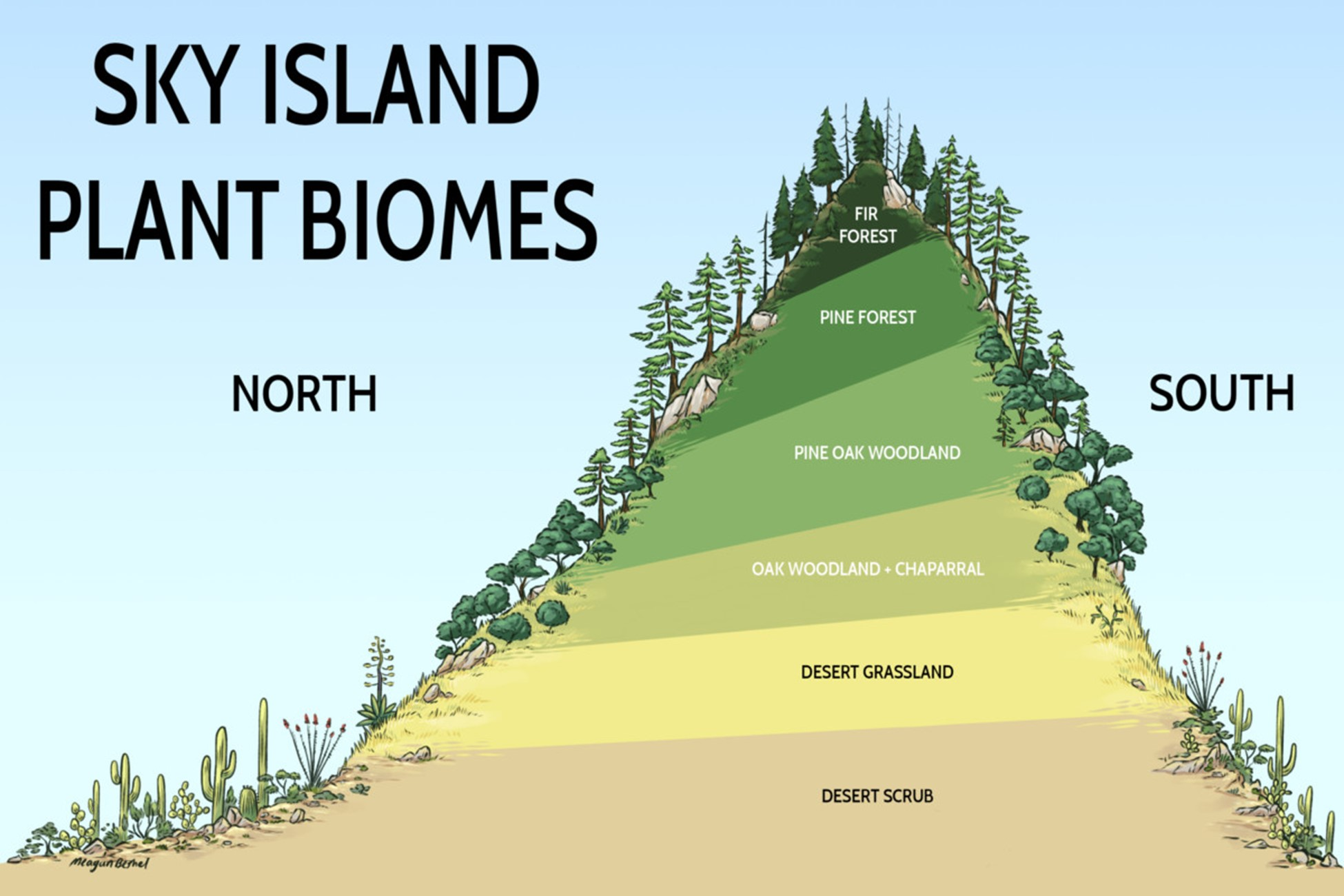
These islands are places of special habitats and recreation. The special habitats are formed from the sun and altitude. The sun shines on the eastern slopes of the mountains early morning through late afternoon, the warmer part of the day and warmer sunshine. The sun shines on the western slopes of the mountains from mid-day through late afternoon, the cooler part of the day. As one goes up the mountains the altitude creates cooler and cooler places for plants and animals.
These islands also isolated flora and fauna so they each have their own unique biodiversity. Because of the deserts between them and the vast difference in altitude some species are only found in some or only one of the Sky Islands. As the mountains formed islands in the desert, they also formed unique, isolated biospheres. Some animals migrate up and down a mountain, but they can’t cross the desert. Some plants only grow at a specific altitude, while their seeds don’t cross the desert.
Sky islands support larger animals such as javelina, deer, black bear, and mountain lions as well as many birds, reptiles, and smaller mammals. There are freshwater jelly fish, unique snails, coatis, Coleman’s coralroot, and the Mount Graham red squirrel. There are mesquite, ironwood, and bristlecone pine trees, cactus of many kinds, and desert and high-altitude plants. When the monsoon season brings rain and the winter rains supplement the monsoon rains, the spring blooms are plentiful. Many faunae migrate up and down the mountains as the temperatures and water availability vary from season to season.
It is a desert at the bottom of the mountains. Here at the Catalina Mountains Mount Lemmon rises to over 9,100 feet. Here is the southernmost ski resort in North America. As one ascends the saguaro end about 4,000 feet. Scrub and brush form the next zone. Finally, up on top, the pines stand tall and strong.
On the east side of the Catalinas is the San Pedro valley. The San Pedro River runs north to join the Gila River and then south to the Colorado River. The water from the southern Catalinas that does not filter into the aquifer under Tucson flows into the Santa Cruz River which flows north to join the Gila River and then to the Colorado River which used to end in the Bay of California in Mexico. It now lacks enough water to complete that journey as we take water out for agriculture and people in the US and Mexico.
The Chiricahua Sky Island is part of the Chiricahua National Monument. The mountains rise from the Sulfa Springs valley to over 9,500 feet. They were formed by volcanic eruption which left, after many millennia of formation, the grey rhyolitic tuff which forms the columns, hoodoos, balanced rocks, and stone spires unique to this sky island. It is the southern most place in North America where quaking aspen grow.

The Santa Catalinas and Rincons join at Reddington Pass. It’s 22 miles east from Sabino Canyon and takes 60 minutes as most of the road is not paved. Sabino Canyon and the Pusch Wilderness Area are managed by the Forest Service right outside Tucson. Imagine taking an Uber to a National Forest! Some trails can also be accessed via Catalina State Park. The Rincon Mountain Wilderness is in the northern part of the Rincons. Saguaro National Park and the Saguaro Wilderness area occupy the rest of these mountains.
The Coronado National Forest is made up of a majority of the Sky Islands in Arizona. This makes it the most ecologically diverse National Forest in the country as living within its borders are more threatened and endangered species than any other National Forest. The Santa Rita Mountains rise 9,456 feet at Mt Wrightson. The Dragoon Mountains are famous for where Cochise made various hideouts for his people. The Huachuca Mountains are part Forest Service, including the Miller Creek Wilderness, the Department of Defense via Fort Huachuca, and the National Park Service at the Coronado National Monument where Francisco Vasquez de Coronado passed as he led his expedition searching for the Seven Cities of Cibola.
The Coronado Forest Service manages the southern part of the Peloncillo Mountains. These mountains form a continuing link from Sierra Madre in Mexico to the Mogollon Rim which is the southern edge of the Colorado Plateau in central Arizona. The Pinaleno Mountains rise over 10,000 feet, thus being the highest of the Arizona Sky Islands. It is here where Bristlecone and Limber Pine grow in small communities on a few south facing slopes. Some of this Sky Island is managed by the Bureau of Land Management. The Coronado National Forest also manages the Santa Rita Mountains which includes Madera Canyon, a mecca for bird watchers, and the Mount Wrightson Wilderness. The Santa Teresa Mountains have the San Carlos Apache Indian Reservation and the Coronado National Forest, including the Santa Teresa Wilderness. The Wetstone Mountains on the Coronado National Forest has no roads to the high elevations. Kartchner Caverns, only discovered in 1974, is a dry, non-growing cavern, managed by the State of Arizona as a state park. Cave tours require a reservation. The smallest and lowest of the Sky Islands managed by the Coronado National Forest is the Winchester Mountains.
As I learn more and travel more about these Islands, I will share what I learn and see.